If you love being outdoors in Juneau, then you are familiar
with most of the local mountains that are popular day hikes. There’s Mt.
Juneau, obviously, then Gastineau Peak, Mt. Roberts, and Sheep Mt. Looking at
Douglas Island from downtown Juneau, Mt. Bradley (aka Mt. Jumbo) dominates the
skyline, and Mt. Troy welcomes hikers traveling up the Dan Moller trail or crossing
over from Eaglecrest. In the Mendenhall Valley no one can ignore Thunder Mt.
and Mt. McGinnis. Even Blackerby Ridge and Cairn Peak are now hiked so often a
trench like path has formed in places along the ridge. These are the peaks that
are hiked frequently and often have several groups at a time on their summits
on a nice day.
 |
| Alone on the summit of West Peak. We had the mountain to ourselves all day. |
But what about West Peak? If you stand on Gastineau Peak or
Mt. Roberts and look directly southeast, you will first notice Hawthorne Peak,
standing tall at 4,210’. Immediately to the right are two smaller mountains –
Middle Peak and West Peak. They are all beautiful mountains, but getting up
them requires a bit more thinking than say trudging up Mt. Juneau. It makes
sense to climb up Hawthorne from the Powerline Ridge above Sheep Creek, first
following the Sheep Creek trail to the alpine and then working your way over to
the Hawthorne summit ridge. But no formal trail exists to access either West or
Middle Peak, which are connected to Hawthorne by a very sketchy steep ridge and
should only be attempted by experienced mountaineers.
I have a long ago memory of hiking West Peak with some
friends in late September 1974. We picked that time of year so the brush would
not be so thick, because we intended to bushwhack up from Thane Road until we
got above tree line. And, oh what a bushwhack it was, too. We pushed straight
up through devil’s club, old berry bushes, nettles, tangled alder, and thickets
of nameless weeds, following the contours of a USGS map and using our compasses
to keep us on course. I remember looking up the slope through the forest at one
point and seeing a gray wolf standing perfectly still. I blinked my eyes and he
disappeared.
When we reached the alpine zone, we enjoyed a pleasant
stroll across benches of heather turned red and gold in the cool fall air. The
sun was shining, but we kept our layers on, as the higher we climbed the colder
it got. There were no tracks or paths to indicate that anyone came up this way
on a regular basis, but that was not too unusual back in the early 1970’s when
the population of Juneau was barely half of what it is now.
 |
| Fall is the best time to hike up West Peak |
I returned to West Peak five years later in late October
1979. We followed the same rough route to the alpine, and were greeted on the
summit of West and Middle Peaks with a small snowstorm and chill winds. This
was a “hiking date” with Scott, who had just moved to Juneau the year before. I
think this was the hike we did where he found out that yes, I really did like
to be outdoors in the mountains, no matter what the weather.
Fast forward 36 years to September 2015. Scott and I woke to
a sunny day and wanted to go for a hike, but hadn’t settled on a specific place
yet. We spread the map out on the breakfast table and studied it for a few
minutes. Then Scott said, “What about West Peak?” A friend had recently pointed
out an unofficial and relatively unmaintained trail that roughly led to the
West Peak alpine area, so we decided to give it a shot. I figured anything had
to be better than blindly crawling straight up through dense brush.
 |
| We enjoyed a much nicer climb up to the alpine than we did 36 years ago. |
We climbed up through the forest from Thane Road, just past
Sheep Creek, and followed a small winding trail to tree line, then an even
smaller track through the brush. We had to stoop to get through some of the
heavier brush, but there was always a faint trail occasionally marked with tiny
bits of orange tape to show us we were on the right path. We continued our
steady climb up through rocky, muddy sections, and I let out a mild curse when
my foot was sucked into a mud hole at one point. It was not a big deal, because
the sunny skies guaranteed my shoe and sock would be dry within the hour.
 |
| A clear, cool, breezy fall day - perfect! |
We popped out of a brushy gully and reached the open alpine
benches, which looked familiar even after all these years. I glanced down the
steep hillside further on, where I had climbed up so many years before, and I shuddered.
Only an energetic twenty-something would be crazy enough to do that more than
once! I was grateful for the marked route we followed this far, rough as it
was.
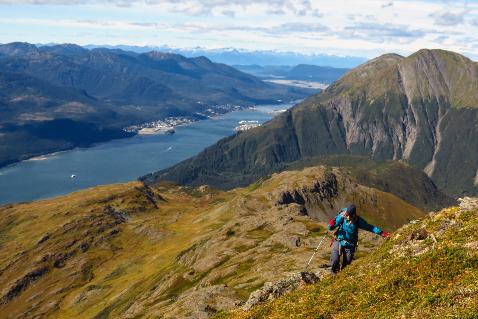
Once we were above the brush, it was up to us to find the
best route to the summit of West Peak as there are still no clearly defined
paths to follow. We worked our way across the ascending benches, trying to
locate the most efficient way up without getting back into the occasional
brushy zone and without losing extra altitude whenever possible. We wandered up
separately, coming together in spots only to break apart again as we climbed up.
It’s so fun to be able to wander freely on high alpine meadows, away from the
constriction of dense trees and brush! The day was brilliant, although the
breeze picked up and blew so strongly it almost snatched my cap off of my head.
We each put on an extra layer and tightened up zippers and hoods.
 |
| Wandering through the alpine zone |
 |
| You go your way, and I'll go my way |
As we climbed together up a small ravine that led towards
the final summit approach, something caught my eye along the ridge above us. It
was large, dark, and – holy smokes! – a bear!!! Neither of us had an adequate
camera that day because we wanted to travel light, so we missed grabbing a shot
of him. That didn’t keep us from enjoying watching him come down from the
summit, until we realized he had no idea we were right in his path. I decided
to yell so he would at least be aware of our presence. He stopped and whirled
around this way and that, trying to catch our scent and figure out where we
were. Bears have terrible eyesight and we were too far away for him to see us
properly, so I yelled again. This time he was sure of our position and he ran
off to the side as fast as he could go, which was impressively fast. A good
reminder that there is no way a human could ever outrun a bear.
 |
| All routes lead to the final summit slope |
 |
| Stepping carefully on the steep hillside |
The final hike to the summit was steep but manageable, and
to our delight the summit was just out of the wind, so we could stretch out to
eat our lunch and relax in comfort, snapping photos with our tiny compact
cameras. We didn’t take the extra time to go over to Middle Peak, but it looked
very tempting. Next time, for sure. Only we will not wait another 36 years, now
that we are reminded that West Peak is just another day hike.
 |
| Middle Peak from the summit of West Peak |
We never really needed our friend’s route finding
instructions until we began our descent. There are many
gullies that drop into the brush below and it’s important to find the right one
to start down, unless we wanted to repeat history and thrash our way to Thane
Road the old way. A few checks of the GPS route kept us on course, and we
quickly recognized the right spot to start down with only a few small
corrections. I generally don’t like depending on GPS tracks, since I learned
map and compass work the old school way, but it does come in handy now and
then. Still, it’s good to have strong skills navigating using a system that
doesn’t rely on battery power.
 |
| Which way do we head down? |
What about West Peak? Done and done. Now we have to go back
and complete the hike by adding on the Middle Peak summit. As I repeat adventures
in my retirement years that I once did as a young hiker newly arrived in Juneau,
I am thrilled to find them much as I remember. I hope they stay that way for
the generations of outdoor adventurers that follow.
West Peak; 3,620 ft.,
3 mi. ESE of Thane and 7 mi. SE of Juneau, Coast Mts. Local name reported in
1917 by D. C. Witherspoon, USGS. Dictionary of Alaska Place Names, 1971, p.
1038.
 |
| Mt. Gastineau - Mt. Roberts - Sheep Mt as seen from West Peak |