
Back in the early 1970’s, a girlfriend and I decided to try and climb Mt. Bullard, which is the first big mountain to the right side of the glacier as you are looking from the Mendenhall Glacier Visitor Center. We went up the West Glacier trail, crossed the Mendenhall Glacier and camped on the low shoulder of the mountain. The weather was hot and sunny, and this being the early 70’s, we did not know much about proper hydration and sun protection. I got away with mild sunburn and a need to drink plenty of water in camp that evening, but my friend suffered a real case of heat sickness and was so sick that night that she could not even think about trying to climb up Bullard.
The next morning after breakfast, I made sure she was comfortable, then got her permission to try Bullard alone, while she rested in camp and gathered her strength for the hike back out. I scrambled a few thousand feet up the heather and rock slopes, and then carefully kicked steps up a long snowfield, all the while looking at the little summit point at the top. From that side, the summit appeared to be a sheer block with a steep cliff face. I was sure there would be no way for me to reach the true summit by myself. I decided I would be content if I could safely reach the summit ridge and look over to the other side. Imagine my surprise and delight when I crested the ridge and found that the other side was a grassy slope that led right to the top of the summit block. I laughed, clambered to the top and hung my legs over the cliff. There was no one to take my picture, but I knew the memory would stay with me for a long time. I never tried to climb up Mt. Bullard again after that trip, until just recently.
A few days ago, through a chance encounter, I was invited to join a group of hikers who wanted to go up Bullard from the Nugget Creek side. I said yes, although their planned start at 6:30 a.m. gave me a moment’s hesitation, as I am most definitely not a “morning person”. But the weather looked promising, the route they wanted to try was entirely new to me, and they were all experienced backcountry travelers, so I had to do it, even if it meant dragging out of bed at 5:30 a.m. to get ready.
I am sworn to secrecy on our exact route, which two of the group worked on last fall during several unsuccessful attempts to reach the summit. Even if I did tell you exactly where we went, there is no way that any sane person would want to try it. I do more than my share of steep hiking and have been known to bushwhack in the backcountry now and then (I once spent twelve hours traveling 2 miles through thick alder to get around Twin Glacier Lake to the East Twin Glacier, but that’s another story). This hike was a good test of all of my experience and stamina.


Eureka! Our bruised, scraped, and bloody arms and legs filled with energy as we marveled at the grand view of the Mendenhall Glacier below us, and the beautiful ridge leading another two thousand feet above us. After a short break, we set out to climb to the top along the ridge. I was excited to see the summit of Mt. Bullard again, and wondered how reliable the memory of my solo experience all those years ago would be.

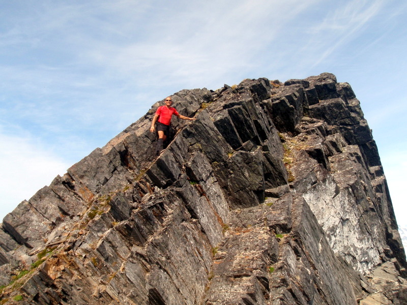
Up and up we climbed, passing one false summit after another, until at last we were right below the main summit block. I looked around me and it all seemed familiar. The view down the other side was the same, with the long snow slope leading up to the ridge. And there was the summit block. But – it was much steeper and rockier than I remembered it! In my memory it was a smooth grassy slope to the top, but that must have just been my relief at finding it was not a sheer cliff on the other side. The reality was that it was a bit of a fourth class scramble up the rock to the true summit.
My head was swimming as I gazed up at the rock and I realized that since we’d been climbing steadily for over four and a half hours, and I hadn’t eaten anything but energy gels, I was a little light headed. I needed some solid food in my stomach if I was going to go rock climbing! My hiking partners couldn’t wait and picked their way up to the top immediately. I joined them a few minutes later after I gobbled half a sandwich, and exactly 38 years and 3 days later after my first ascent, I stood on the top of Mt. Bullard once again.
Unbelievable views greeted us in all directions. We couldn’t stop laughing and goofing around as we snapped photos of each other on the top. This is what I had missed all those years ago – someone to share the summit with and record the moment. It was so perfect and I was so happy that I didn't want to think about how we would get down.

But we had to go down eventually. We lounged on the ridge right below the summit block and enjoyed a full lunch, more photos, and a spirited discussion of all the possible routes available on the many valleys and ridges across from us between Thunder Mountain and Nugget Peak from the Nugget Creek drainage. Then Bob and Ron did a little reconnaissance further along the ridge, while Dave and I slowly started to pick our way back.
We regrouped at a tiny alpine pond to filter more water for the long hike out. Somewhat reluctantly, we bravely plunged back into the awful brush and steep woods, which we knew would be even worse going down than climbing up. I go into auto pilot in situations like this, singing songs out loud, trying not to think about how much it hurt to slip and slide down, trying not to twist a knee or ankle, and trying not to lose the so-called trail. Ok, so we got a little off track, and for a while it looked like we might end up plunging into Mendenhall Lake instead of heading to Nugget Creek where we had left our stream crossing footgear. But thankfully Dave’s GPS helped us get back on course and after some "more to the left, now more to the right" on the crazy steep goat trails we found our way safely down.
As soon as we crossed the creek, I felt refreshed and energized, and the final hike back to the cars was a skip and a hop home. The weather had been perfect and we couldn’t have picked a better day for our climb. We toasted our success among the throng of tourists wandering around us at the visitor center parking lot, and gazed in awe at Mt. Bullard. You’d think after climbing up a mountain it would look more familiar and friendly, but instead it looked steeper and harder than ever. I will go back, but this time I don’t think I’ll wait another 38 years.
*Mt. Bullard, 4,225 ft. Named for Benjamin Bullard, 1848-1933, a mining engineer who came to the Klondike from California in 1897 and later moved to Juneau. In 1907 he began mining on Nugget Creek where he later built a hydroelectric power plant (DeArmond, Some Names Around Juneau, 1957, p. 9-10) (Dictionary of Alaska Place Names, Donald Orth, 1967, p. 167)
No comments:
Post a Comment