It all started innocently enough. The weather forecast was perfect and Scott and I had the day off together, so we decided to go for a hike up Blackerby Ridge. If we started early enough, we could easily get up Cairn Peak and then over to Observation Peak, which I had never climbed. This was the plan – a good effort, a new peak for me, and a beautiful late summer day spent high in the mountains.
I’ve lived in Juneau almost forty years and have been hiking in the mountains since I first arrived, but somehow Observation Peak has managed to elude me. I often looked at it as I stood on one of the many peaks around it and wondered why I had never climbed it. I decided that this was the summer and this was the day. I was ready to check it off my list.
 |
| Blackerby Ridge with Cairn Peak and Observation Peak in the distance |
 |
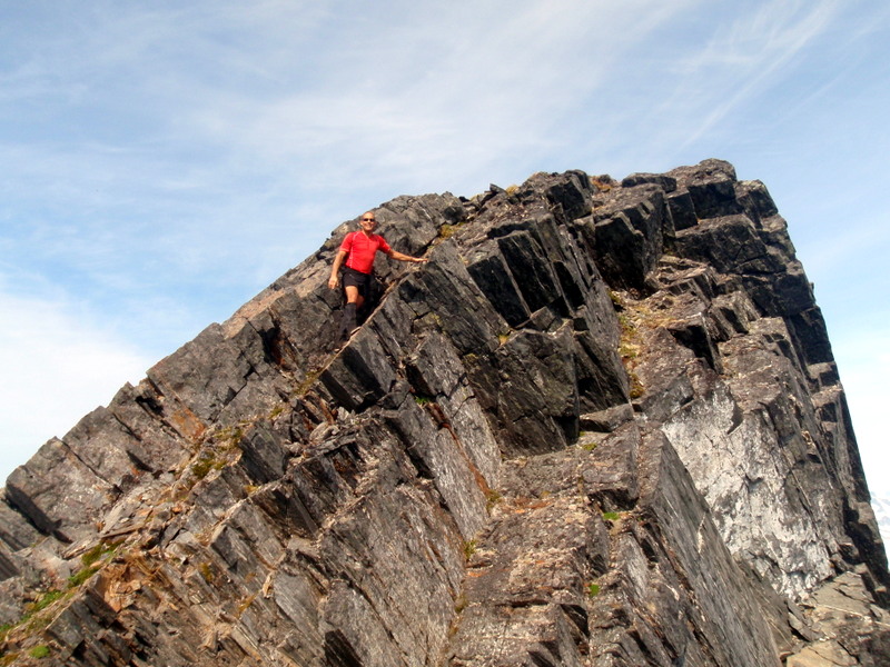
| Cairn Peak on the left and Observation Peak behind it on the right |
We left the house before 8 a.m., which counts as an early start in our family. The Blackerby trail went by quickly, and before we knew it we were up above tree line with a beautiful ridge in front of us and not a cloud in the sky. A short way down the ridge we ran into two deer hunters, the first of many people we would see that morning. We walked and chatted with them for a while and they told us about the wolf they spotted earlier on the ridge. They joked that it would probably be the only wildlife they would see on such a sunny day. A short while later, a group of experienced trail runners caught up to us and passed as we headed up Cairn Peak. With a line of people snaking up the narrow ridge to the summit, I felt like I was on a busy downtown street corner at lunch rather than a remote mountainside. But most were friends or acquaintances and it was fun to chat with them as they went by, sharing a few hugs and a little friendly trail gossip.
The “crowd” quickly dispersed over the summit, and the runners scampered away to Observation Peak. Many of them were going to do the full circuit over to Granite Creek. This route involves a steep descent off of Observation, with a little bit of exposed third class scrambling, followed by a traverse of the Salmon Ridge, and then a steep climb up to the ridge above Granite Creek basin. About ten runners were headed in that direction. Another couple was headed over to Thoroughfare Mountain above the Norris Glacier to camp for the evening. The outdoor community of Juneau certainly knows how to get out and enjoy the sun!
Scott and I often talked about doing the traverse from Observation over to Granite Creek, but first things first – I still had to climb Observation. The conversation (which had actually started the night before) went something like “Well, when we get to Observation we’ll just see how it goes. Maybe we’ll end up going over to Granite Creek.” Scott even went so far as to suggest before we started that we leave a second vehicle at the Perseverance trailhead, but I hesitated to commit to such a long hike. I guess I thought that if I didn’t fully commit to the “grand traverse”, it would somehow make everything easier if we ended up doing it anyway, which is a completely backwards way of thinking. But I can’t explain how my mind works when it comes to my outdoor adventures – if there was any rational thought involved I probably wouldn’t do half the things that I end up doing. And all I really wanted to do was to climb Observation Peak, which would be a big enough accomplishment for me.
We took a short break on the summit of Cairn, and then started over to Observation. I was hoping it would be a fairly quick trip, but first we had to drop about 700’ off of Cairn, and climb another 1,100’ up Observation. I was starting to regret the hill training run I had done two days earlier on the East Glacier loop, which I try to do once a week starting in August to get in shape for skiing. All those steep stair climbs were coming back to haunt me and my legs were feeling the burn.
 |
| Near the summit of Cairn Peak - Observation is behind us. Still some miles to go! |
Thankfully, the climb up Observation was straightforward - rocky, with plenty of solid places to place our hands and feet, and a few spots where we could climb up on the snow. We steadily made our way to the summit, not talking much and looking at the magnificent views as we climbed. The runners were long gone and the mountains were all ours to enjoy.
We shared big grins, hugs, and congratulations with each other when we reached the summit. A brisk, cold wind was blowing and we put on extra layers so we could enjoy our lunch and soak it all in, taking photos of the surrounding icefield and peaks. There were breathtaking views in every direction!
 |
| Snapping pictures from the summit of Observation Peak |
 |
| On the summit! We still have a long hike out ahead of us |
Some more food and a short rest gave us time to evaluate our choices. If we could safely find our way down off of Observation, we still had close to two miles of unknown rocky terrain over to Granite Creek, another 500’ climb up, and a good six mile hike out after that. I am most definitely NOT an "ultra-runner", and I looked longingly back at Cairn Peak and the well-known Blackerby trail, with its rolling grassy ridge. We scouted over the edge of Observation and thought we could see a possible way down. Before we could come up with any reasonable objections, we were headed down to do the full traverse. Once we started, we were committed.
We carefully picked our way along the steep ridge, but there was no trail to follow, not even an occasional friendly cairn marker. It was the worst sort of Southeast Alaska mountain terrain – loose rocks and dirt, uneven footing, and threatening cliffs on all sides. We managed to negotiate it safely, but not once did we ever feel like we were on any sort of regular route. I think the most traffic this side of Observation receives is from occasional ultra-runners and maybe a backcountry hiking group or two during the summer season, certainly not enough to establish a recognizable trail that we could find.
 |
| Looking back at the steep, rocky route on Observation after climbing down to the Salmon ridge |
The relief we felt as we reached the base of Observation was short lived as we started to work our way across the Salmon ridge, which is a series of broken rock bands that made us feel like we were going against the grain trying to reach the other side. Up and down, and up and down we hiked. Every time I looked back at Observation it didn’t seem like we had made any progress. And when I looked ahead at the ridge above Granite Creek, it appeared as if there was no easy way up what looked like a very steep slope. My brain was getting tired, my legs were aching, and I was feeling the weight of the decision we had made to extend our hiking adventure.
 |
| Across Salmon ridge and ready to hike out Granite Creek basin and down to Perseverance trail |
Fortunately, my mind is quite experienced at convincing my poor, battered muscles to do things that seem impossible, because all at once we were at the end of the ridge and I was still moving along at a steady pace. And - happy surprise - a lovely little trail magically appeared on the steep slope leading up and over to Granite Creek basin! We were all smiles again. The rest of the way was going to be a tiring hike, but it was all on familiar ground. A long glissade down the snow slopes took us straight into the upper basin, and on to the well-known trail leading out. Stumbling through the mud, brush, and hard snow lower down, we finally reached the Perseverance trail, paused to shake the dirt and rocks out of our shoes and eat the last of our food for a final energy burst.
Regular hikers started to appear, just normal people enjoying a nice, easy hike, and a few runners out for a late afternoon jog. They looked so fresh and full of energy, while we felt tired, dirty, and just a little anxious about what we would do when we reached the end of the trail. We talked about how we were going to get back to our car parked at the Blackerby trailhead over by Twin Lakes. Hitchhike? Call a friend? Maybe even grab a taxi from downtown? That phrase came up again – “We’ll see how it goes when we get there.”
As luck would have it, some friends came by on mountain bikes, heading up the trail in the opposite direction. We waved hello to them as they went by, and I thought “If we hustle down to the bottom of the trail fast enough, we can grab a ride out with them as they come back down!” And that’s exactly what happened. We gratefully collapsed into their truck on Basin Road and thanked them over and over again.